


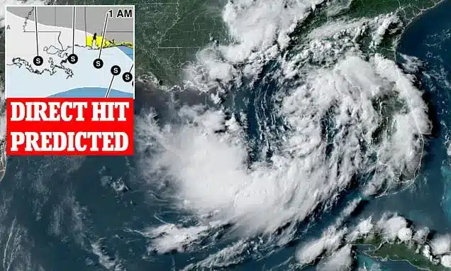
A tropical storm, anticipated to be named Bertha, is projected to form along the U.S. Gulf Coast within hours, with millions of residents bracing for significant impacts. The National Hurricane Center has already designated the system as Tropical Depression Two, and forecasters predict it will intensify into a named storm by Monday afternoon. Wind speeds are expected to exceed 39 mph, marking its transition to Tropical Storm Bertha.
Storm’s Projected Path and Potential Impacts
Current projections indicate that the storm is on a trajectory to make landfall near New Orleans by Wednesday afternoon. The entire Gulf region, encompassing the Florida Panhandle, Mississippi, Alabama, Louisiana, and Texas, is expected to experience heavy rainfall and sustained winds exceeding 50 mph. Coastal areas are also facing a threat from dangerous seas and waves that could reach up to 16 feet high as the storm moves from east to west throughout the week.
Meteorologists emphasize that even before achieving official storm status, tropical systems can bring severe weather. AccuWeather Meteorologist Tyler Roys noted, “Tropical systems can bring dangerous rainfall, flash flooding, and other hazardous impacts regardless of whether they receive an official designation.”
Preparations and Warnings Issued
In anticipation of the storm’s arrival, the National Weather Service has issued tropical storm warnings along the entire Florida coast, stretching from Tallahassee to Miami. Officials have cautioned that vessels could be capsized or damaged by the expected conditions. Significant rainfall is forecast for multiple areas, with accumulations of up to eight inches predicted for parts of Florida, including Tallahassee and Panama City, as well as for New Orleans and its surrounding seven-parish metropolitan area, home to nearly one million people.
Understanding Tropical Depressions
Tropical Depression Two is expected to continue strengthening throughout Monday, fueled by the extremely warm waters of the Gulf of Mexico. Tropical depressions represent the initial stage of tropical cyclone development in the Atlantic basin. At this phase, a storm has established a defined center of low pressure and some rotational circulation, though it typically appears as a less organized, swirling mass on weather radar systems.
Key Dates and Forecasts
- Expected Storm Formation: Tropical Depression Two is anticipated to become a named storm, Tropical Storm Bertha, on Monday, July 20.
- Projected Landfall: The storm is forecast to make landfall in Louisiana by Wednesday, July 22.
- Geographic Scope: Impacts are expected across the U.S. Gulf Coast, including Florida, Mississippi, Alabama, Louisiana, and Texas.
Expert Commentary on Storm Hazards
The formation of Tropical Storm Bertha underscores the dynamic nature of weather systems in the Gulf of Mexico. Experts highlight that the combination of warm ocean temperatures and atmospheric conditions can rapidly accelerate the development of tropical disturbances. The potential for high winds, torrential rain, and significant storm surge poses a serious threat to coastal communities and infrastructure.
Forecasters are closely monitoring the storm’s intensification and track. Residents in the projected path are advised to stay informed about the latest updates from official sources, secure property, and prepare emergency kits. The National Hurricane Center provides continuous advisement on storm progress and safety recommendations.
Broader Implications for the Region
The anticipated arrival of Tropical Storm Bertha serves as a reminder of the vulnerability of coastal regions to severe weather events. Beyond the immediate threat of wind and rain, the potential for widespread power outages, transportation disruptions, and localized flooding requires careful planning and response from both authorities and individuals. Emergency management agencies are coordinating efforts to ensure public safety and provide necessary resources as the storm approaches.
The development of this storm system is a critical event for the Gulf Coast, demanding heightened awareness and preparedness. The coming days will be crucial in assessing the full extent of its impact and the effectiveness of the ongoing safety measures being implemented.